21st Century Mapping
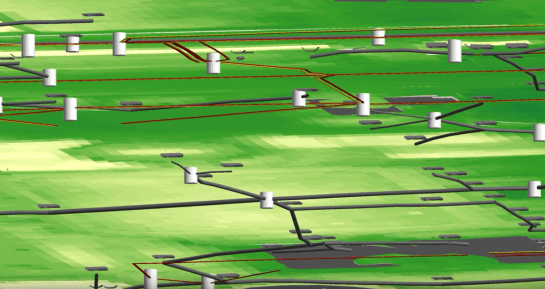
How many utilities have a 3D map of their infrastructure? Not many I bet. But FAU does. Here is a recently completed project we did with students and the Facilities Maintenance staff at FAU (costs involved). They needed better mapping and will tie this to their work order system. It was an excellent opportunity for two groups within one organization that otherwise seem to have little in common wot work toward a great project. We will be inputting this data into an online asset management system this summer along with some data for Dania Beach so they will have a portion of their utility system in 3D also. This is part of a tiny project we did for their downtown area.
GIS is a powerful tool and one utilities should embrace wholeheartedly. There is so much more than mapping to do. Data gathering in critical, but with Leica and Trimble units, a lot of data can be gathered easily. LiDAR can be expensive, but the value is tremendous. You can see that the FAU system is laid on a 3D LiDAR topographic map (6 in vertical accuracy). Asset condition assessments were also done concurrently, which adds a lot of information to the system (all assets were also photographed and linked). Drawing files can be downloaded and extruded from 2D to 3D. Engineers know GIS or can learn it, which makes a fully expanded GIS system for the utility easy to derive if the time is spent. This is a valuable tool when linked to work orders and asset management programs.
So is your utility in 3D?