Residents of Palm Beach County in Florida erupted in anger at a commissioner’s meeting after an unanimous vote to make masks mandatory.
— Read on www.cnn.com/videos/politics/2020/06/24/mask-mandate-florida-anger-erupts-coronavirus-vpx.cnn


USEPA (2013) notes six basic steps to develop and implement a watershed master plan.  The first step is to build partnerships with surrounding communities.  Few communities can go alone to resolve such impacts.  For example, water may enter a community watershed from upstream and leave to impact another community downstream, overwhelming their system.

The second step is to characterize the watershed.  The process to accomplish this involves:

  • Identify land uses including vacant land, wetlands, etc.
  • Acquire soils data
  • Acquire topographic data (Lidar)
  • Identify relevant waterways
  • Identify basins for flood routing
  • Acquire FEMA flood maps
  • Identify storm of interest (25 year and 100 year for category 4 in the CRS manual)
  • Model flood response (Cascade)
  • Develop flood risk/hazard mapping
  • Identify areas of concern (repetitive loss)

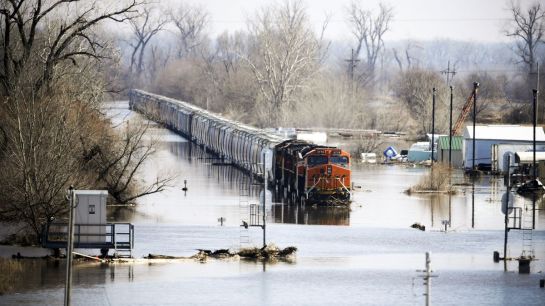
Groundwater is relevant when the ground and surface waters are directly connected, and the soil lacks capacity for holding much infiltration. In addition, many plans are completed with the intent of improving water quality, thereby crossing paths with TMDL plans Note that USEPA recognizes the difficulty in obtaining watershed-related information with precision and acknowledges that a balanced approach is needed to address this concern.

There is a connection between WMPs and CRS. To earn CRS credit, communities must adopt regulatory standards that, at least, are creditable under element 452a Stormwater Management Regulations, require that runoff from all storms up to and including the 25-year event be managed, and ensure that future peak flows do not increase over current rates. In addition, coastal communities are required to evaluate the effects of sea level rise. Therefore, one strategy for reducing the effort associated with implementing this CRS element is working with neighboring communities that share watersheds. Working with other communities can help to maximize credits for the CRS element because of the way the impact adjustment is calculated. In addition, by working with neighboring communities, the cost associated with completing the hydrologic modeling necessary to earn credit for this element could be split.

Step 3 involves identifying measures to reduce impacts (watershed, regional, and local).  At the watershed level, this is difficult to do, but the ability to use collected data to drill down is useful.  Note that addressing local issues requires the ability to take the current data and drill down to details.  An example process that USEPA (2013) suggests for capital plans is:

  1. “Inventory existing management efforts in the watershed, taking into account local priorities and institutional drivers.
  2. Quantify the effectiveness of current management measures.
  3. Identify new management opportunities.
  4. Identify critical areas in the watershed where additional management efforts are needed.
  5. Identify possible management practices.
  6. Identify relative pollutant reduction efficiencies.
  7. Develop screening criteria to identify opportunities and constraints.
  8. Rank alternatives and develop candidate management opportunities.”


Item 1 above is generally completed through the following measures:


  • Review and evaluation of existing watershed data, including identification of features requiring immediate maintenance
  • Development of preliminary watershed model diagram
  • Establishment of GIS database for watershed resource features and parameter inventory through desktop and field reconnaissance

Floodplain analysis includes developing a watershed model and identifying associated inundation polygons. It builds upon information generated from the watershed evaluation so that planning and management decisions can be formulated. Floodplain analysis may include the following tasks:

  • Completion of the watershed resource feature and parameter inventory GIS database for the watershed using the acquired information
  • Assemblage of GIS database information into a specific format for a selected computer program which predicts the watershed’s response to the hydrologic cycle
  • Watershed model development, calibration, and verification
  • Floodplain delineation

Step 4 involves implementation, which means local communities participate in defining projects and solutions as well as the timing and means to fund them.  This is where many watershed plans fail – the ability to fund outside a jurisdiction is fraught with many difficulties.  Capital plans, bond issues, etc. are all part of the plan.

The final two steps are implementation and monitoring progress so that updates can be made.  USEPA recognizes that the processes involved in watershed assessment, planning, and management are iterative and that targeted actions might not result in complete success during the first or second cycle.

The reason this is relevant to water utilities was noted earlier – funds are needed, sourcewater protection is relevant to watershed plans and the results may impact your water supply.  Watershed planning occurs at a variety of levels of government – sometimes with consultants, other times via universities or regional agencies.  But in any case it is important to be involved in the process.


AP_19076776858624.0

Reducing flood risk is an ongoing challenge for local governments.  The National Flood Insurance Program (NFIP) has developed a means to assess flood risk and adjust flood insurance rates accordingly.  Many of these steps, developed as a part of the Community Rating System (CRS) are policy oriented.  That means local regulations, newsletters, outreach etc.  Getting more points involves capital programs which cost much more money, so many local officials try to balance the tradeoff of capital versus insurance reductions.  IT makes one wonder if the insurance loss might be a better means to assess, but that is a separate issue.

The development of capital projects means large amounts of water will be transferred from one point to another.  Most communities look at trying to get the water out of their community as fast as possible, but this can have downstream impacts (or if you are the recipient, impacts form upstream that you cannot control).  As a result, watershed plans are needed As a means to integrate local communities on a watershed basis.  Note a watershed is not local stormwater, so a stormwater master plan is not a watershed plan.  The watershed plan is a much larger effort, and one that normally included a means to fund basin-wide. Improvements.  The latter is why few true watershed plans actually exist, which impacts the ability of local communities to increase their ratings.

To address the watershed element, USEPA published the Handbook for Developing Watershed Plans to Restore and Protect our Waters in 2008 to provide users with a comprehensive resource to develop more effective watershed plans.  The goal was to improve and protect the nation’s water quality. However, the true benefit of watershed master plans extends well beyond this goal to include additional project opportunities that address water quality issues, low impact development, stream restoration, nature based park planning, mitigation banking, and conservation easements.  Specific objectives include:

  • Identify needs and opportunities related to flood risk, water quality issues, low impact development, stream restoration, mitigation banking, and conservation easements.
  • Develop and assess proposed projects to address the identified needs and preserve identified opportunities.

Note this extends well beyond water quantity, given that large volumes flushed in a watershed can have adverse quality impacts (think water supply which from which 60% of public users get their raw water supplies – the turbidity is a huge treatment problem).  In addition, plans are developed to inform using data-driven decision making using high-resolution data to create basin priorities, balance water quality, stormwater conveyance, and wildlife habitat program synergies and enable prudent spending of scare public funds.

According to the CRS Coordinator’s Manual, “the objective of watershed master planning is to provide the communities within a watershed with a tool they can use to make decisions that will reduce flooding from development on a watershed-wide basis.” Successful watershed master plans (www.floodsciencecenter.org) consists of:

  1. Evaluate the watershed’s runoff response from design storms of various magnitudes and durations under current and predicted future conditions,
  2. Assess the impacts of sea level rise and climate change,
  3. Identify wetlands and other natural areas throughout the watershed,
  4. Protect natural channels,
  5. Implement regulatory standards for new development such that peak flows and volumes are sufficiently controlled,
  6. Include specific mitigation recommendations that should be implemented in order to ensure that communities are resilient in the future, and
  7. Have a dedicated funding source like a stormwater utility in place in order to implement the mitigation strategies recommended by the plan.

One of the challenges is that watershed level planning crosses jurisdictional boundaries and are therefore challenging to get buy-in for.  If parts of the watershed are outside the community’s jurisdiction, coordination with the other communities is required. In addition, hydrologic modeling is required to determine the present and future runoff conditions. Not all communities will have an individual on staff that is capable of completing this kind of effort.

Part 2 of this blog will outline the planning process.


The Plutonium finishing plant ins Hanford, WA has been cleaned up of nuclear contamination.  $1.2 billion was spent, including $179 million to remove 4 buildings.  Now, where did all that rubble go?

Newark NJ is replacing 18,000 lead service lines in 2.5 years as a means to reduce lead exposure to its citizens.  Has Flint finished its lead service line replacement program yet?  Started it?

Oregon’s Senators have introduced legislation to upgrade tribal water and sewer systems that have been in place over 50 years.  I think the native American need it.


IMG_3595

Facts for rural roadway funding:

  • 20% of the population lives in rural areas
  • 46% of roadway fatalities occur on rural roadways
  • 39%of all rail/road crossing deaths occur in rural areas
  • 80% of bridges closed to traffic due to structural issues are rural
  • The cost of bring roads up to code in in the hundreds of billions.

With potential reductions in federal and state funding on the horizon, the solution for this is?  ItOn is clear why people continue to move away from rural areas and into cities where health care, education, job opportunities and income levers are greater.  It means we will continue to see the decline of rural communities and a lagging of the economic condition of rural citizens.


The new strain appeared in February in Europe, migrated quickly to the East Coast of the United States and has been the dominant strain across the world since mid-March, the scientists wrote.
— Read on www.chicagotribune.com/coronavirus/sns-mutant-more-contagious-coronavirus-has-emerged-20200505-lr5pctceo5bltbh2mjkiajbxwq-story.html